Coordinate
Advertisement
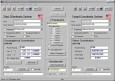
TRANSDAT (English)
TRANSDAT Geosoftware executes coordinate transformations and geodetic datum shifts between lots of coordinate and reference systems of Germany, Europe, America, Australia and world wide. The current and historical coordinate and reference systems
Advertisement
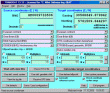
TOPOWIN v.16.00
TOPOWIN is a state-wide register of the German topographic cartographies and of localities with geo references in different coordinate systems. It also is a topographic information system.
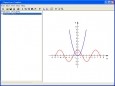
Equation Grapher
Equation grapher is an easy-to-use software for 2D function graphing. 2D function graphs can be plotted in Cartesian and polar coordinate systems
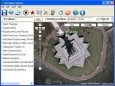
Arm Map Explorer v.2.2
Arm Map Explorer recreates all the functionalities of Google Maps while adding new ones like viewing a map with a coordinate grid on it, getting precise coordinates of any location on a map, moving to a needed location based on specified coordinates.

GeoDataSource World Cities Database (Gold Edition) v.April.2013
GeoDataSource Cities Database Gold Edition contains city names, feature type classifications, country names in FIPS and ISO, regions, sub-regions, state, county, longitude and latitude in degree and decimal, UTM coordinate grid and JOG reference.

GeoDataSource World Cities Database (Titanium Edition) v.March.2013
GeoDataSource Cities Database Titanium Edition contains city names, feature type classifications, country names in FIPS and ISO, regions, sub-regions, state, county, longitude and latitude, UTM coordinate grid, JOG, population and time zone.
Geo Data International Streets
For many countries street coordinates are present with coverage degrees of 100 percent. The geo data offered here are in high-precision quality and are present in several coordinate and reference systems (Geographic, UTM / WGS84, ETRS89). Street
Geo Data International Houses
For many countries house coordinates are present with coverage degrees of 100 percent. The geo data offered here are in high-precision quality and are present in several coordinate and reference systems (Geographic, UTM / WGS84, ETRS89). House Coordinates
Geo Data German Houses
For the area of the Federal Republic of Germany more than 19 million House Coordinates with a coverage of 100% are available. The geo data offered here are in high-precision quality and are present in several coordinate and reference systems.
Geodaten German Streets
For the area of the Federal Republic of Germany more than 1.5 million street coordinates with a coverage of 100% are available. The geo data offered here are in high-precision quality and are present in several coordinate and reference systems.

GeoDataSource World Cities Database (Platinum Edition) v.April.2013
GeoDataSource Cities Database Platinum Edition contains city names, feature type classifications, country names in FIPS and ISO, regions, state, county, longitude and latitude, UTM coordinate grid, JOG and population.